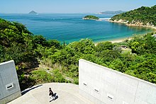
Naoshima, Kagawa
You can help expand this article with text translated from the corresponding article in Japanese. (October 2012) Click [show] for important translation instructions.
|
Naoshima
直島町 | |
|---|---|
Town | |
 Beachside Torii on the southern part of the island | |
 Location of Naoshima in Kagawa Prefecture | |
| Coordinates: 34°27′30″N 133°59′00″E / 34.45833°N 133.98333°E | |
| Country | Japan |
| Region | Shikoku |
| Prefecture | Kagawa Prefecture |
| District | Kagawa |
| Government | |
| • Mayor | Shin'ichi Kobayashi |
| Area | |
| • Total | 14.22 km2 (5.49 sq mi) |
| Population (2020) | |
| • Total | 3,026 |
| • Density | 210/km2 (550/sq mi) |
| Time zone | UTC+09:00 (JST) |
| Website | www |
Naoshima (直島, Naoshima) is an island in Japan's Seto Inland Sea, part of Kagawa Prefecture. The island is best known for its many contemporary art installations and museums. The Town of Naoshima (直島町, Naoshima-chō) administers Naoshima and 26 smaller islands nearby.[1] As of 2020, the town has an estimated population of 3,026[2] and a density of 210 persons per km2. The total area is 14.22 km2.[3]
Naoshima Island is known for its many contemporary art museums. For example, the Chichu Art Museum (literally, "in the earth") houses a number of site-specific installations by James Turrell, Walter De Maria, and paintings by Claude Monet. Designed by Tadao Ando, it is located on one of the highest points of the island, and various exhibits and facets of the museum's architecture take advantage of its commanding view. Another contemporary museum (and hotel) is Benesse House, also by Ando. Another is the Naoshima Fukutake Art Museum, with an outdoor sculpture garden, and a third is the James Bond museum, inspired by the island's use as one of the settings for the 2002 Bond novel The Man with the Red Tattoo by Raymond Benson.[4] It is also known as the island that the fictional locations of Summer Pockets are based on.
The museums and beauty of the island draw many tourists, whose visits help support the local economy. However, it is Mitsubishi Materials, loosely affiliated with other Japanese companies of the Mitsubishi name, that dominates industry on the island, as Naoshima has been the site of massive refining by Mitsubishi since 1917.
Benesse Corporation (one of the largest education companies in Japan and based in Okayama) has directed the creation and operation of the island's museums and other projects since the late 1980s.
Town of Naoshima and nearby islands
[edit]Naoshima was made a village in 1890, and upgraded to a town in 1954.[1] The town is part of Kagawa District.[5] Naoshima is the sister town of Timmins, Ontario, Canada.
As of 2010, only three of the town's 27 islands are inhabited: Naoshima, Byōbujima, and Mukaejima.[6] Ishima is also inhabited, but only in the northern portion which belongs to Okayama Prefecture.
Byōbujima
[edit]Byōbujima is a minor island north of Naoshima, close to Okayama Prefecture, with a population of 19 as of 2015.[update][7]
Ishima
[edit]The second-largest island of the town, Ishima, lying northeast of Naoshima, is divided between Kagawa Prefecture in the south and Okayama Prefecture in the north. The only inhabitants are in a small settlement on the north coast, belonging to Okayama.
Ishima was divided after fishing-related disputes in the Edo period.[8] In 2011, 87% of the island was burned in a forest fire, though the northern settlement was spared.[9]
Mukaejima
[edit]Mukaejima is a minor island northwest of Naoshima with a population of 15 as of 2015.[update][7]
Demographics
[edit]Per Japanese census data,[10] the population fo Naoshima has declined over the past half-century.
| Year | Pop. | ±% |
|---|---|---|
| 1970 | 6,007 | — |
| 1980 | 5,302 | −11.7% |
| 1990 | 4,671 | −11.9% |
| 2000 | 3,705 | −20.7% |
| 2010 | 3,325 | −10.3% |
| 2020 | 3,103 | −6.7% |
References
[edit]- ^ a b "Introduction of Naoshima Town" (in Japanese). Japan: Naoshima Town. March 3, 2016. Retrieved 5 April 2021.
- ^ "Kagawa Prefecture Population Statistics (September 1, 2020)" (in Japanese). Kagawa Prefectural Government. 1 September 2020. Retrieved 5 April 2021.
- ^ "Areas of Prefectures, Towns, etc". Geospatial Information Authority of Japan (in Japanese). Ministry of Land, Infrastructure, Transport, and Tourism. January 1, 2021. p. 64. Retrieved 5 April 2021.
- ^ Clements, Jonathan (15 October 2012). "From Naoshima With Love". The Official Schoolgirl Milky Crisis Blog. Retrieved 30 October 2012.
- ^ "Postal codes: Kagawa Prefecture" (in Japanese). Japan Post. Retrieved 5 April 2021.
- ^ "香川県離島振興計画 [Island Promotion Plan, Kagawa Prefecture]" (PDF) (in Japanese). Kagawa Prefecture. December 2017.
- ^ a b "Island Population Statistics" (in Japanese). Kagawa Prefecture. Retrieved 5 April 2021.
- ^ "Photo gallery: disputed borders". Mainichi Shimbun (in Japanese). December 2008. p. 5. Retrieved 5 April 2021.
- ^ "瀬戸内海の石島、87%を焼失…ようやく鎮火". YOMIURI ONLINE. 読売新聞社. 2011-08-12. Retrieved 2011-08-12.
- ^ Naoshima population statistics
External links
[edit] Media related to Naoshima, Kagawa at Wikimedia Commons
- Official website (in Japanese)
- Benesse Art Site Naoshima (in English)
- I Love Setouchi - Setouchi Brand
- Japon – Noashima, l’île mystérieuse (in French)
 Naoshima travel guide from Wikivoyage


