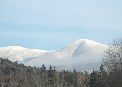
Mount Eisenhower
| Mount Eisenhower | |
|---|---|
 Mount Eisenhower, June 2006 | |
| Highest point | |
| Elevation | 4,757 ft (1,450 m)[1] |
| Prominence | 353 ft (108 m)[2] |
| Listing | New England 4000-footer #12[2] |
| Coordinates | 44°14′26.64″N 71°21′0.65″W / 44.2407333°N 71.3501806°W[1] |
| Geography | |
 | |
| Location | |
| Parent range | Presidential Range |
| Topo map | USGS Stairs Mountain |
| Climbing | |
| First ascent | Possibly Darby Field in June 1642, though no one has proven this yet.[3] |
| Easiest route | Edmands Path, Mt. Eisenhower Loop[3] |
Mount Eisenhower, formerly Mount Pleasant, is a mountain in the Presidential Range in the White Mountains of New Hampshire approximately 4,757 feet (1,450 m) high.[1] Named after President Dwight D. Eisenhower, its summit offers a 360° view. It is inaccessible by road.
The Crawford Path, carrying the Appalachian Trail, crosses the mountain near its summit.[4] It separates from the summit loop trail at 4,400 feet (1,300 m), 0.3 mi (0.5 km) south of the summit, and rejoins it 0.3 mi (0.5 km) northeast of the summit, having made a net elevation gain of about 40 feet (12 m) and reached a maximum on Eisenhower of about 4,520 feet (1,380 m).
The mountain was known as Mount Pleasant until the New Hampshire Legislature voted in 1969 to name it after President Eisenhower, and the U.S. Board on Geographic Names agreed in 1970.[5]
The shortest trail route to the summit of Eisenhower is from a parking lot on Mount Clinton Road, to its west-northwest, via primarily the Edmands Path. Several routes are available from points more or less southwest of it on Route 302; the most used of these (probably roughly equal in popularity to the Edmands route) is via the Crawford Path, starting from a parking lot on Mount Clinton Road, very near 302 and just north of the Highland Center in the Crawford Notch area. Mount Monroe lies on the ridge northeast of Mt. Eisenhower, and Mount Pierce to the southwest. All three of these peaks are included on the peak-bagging list of four-thousand footers in New Hampshire. Mount Franklin, an "unofficial" peak (not prominent enough to be included in the list), lies between Mount Eisenhower and Mount Monroe.
Climate
[edit]
| Climate data for Mount Eisenhower 44.2436 N, 71.3506 W, Elevation: 4,318 ft (1,316 m) (1991–2020 normals) | |||||||||||||
|---|---|---|---|---|---|---|---|---|---|---|---|---|---|
| Month | Jan | Feb | Mar | Apr | May | Jun | Jul | Aug | Sep | Oct | Nov | Dec | Year |
| Mean daily maximum °F (°C) | 18.4 (−7.6) |
20.6 (−6.3) |
27.3 (−2.6) |
40.2 (4.6) |
53.0 (11.7) |
61.4 (16.3) |
65.8 (18.8) |
64.6 (18.1) |
59.0 (15.0) |
46.6 (8.1) |
33.1 (0.6) |
23.8 (−4.6) |
42.8 (6.0) |
| Daily mean °F (°C) | 10.8 (−11.8) |
12.2 (−11.0) |
19.2 (−7.1) |
31.6 (−0.2) |
44.7 (7.1) |
53.8 (12.1) |
58.4 (14.7) |
57.1 (13.9) |
51.1 (10.6) |
39.1 (3.9) |
26.7 (−2.9) |
16.9 (−8.4) |
35.1 (1.7) |
| Mean daily minimum °F (°C) | 3.1 (−16.1) |
3.9 (−15.6) |
11.1 (−11.6) |
22.9 (−5.1) |
36.3 (2.4) |
46.1 (7.8) |
51.1 (10.6) |
49.7 (9.8) |
43.2 (6.2) |
31.5 (−0.3) |
20.2 (−6.6) |
9.9 (−12.3) |
27.4 (−2.6) |
| Average precipitation inches (mm) | 5.20 (132) |
4.55 (116) |
5.65 (144) |
6.61 (168) |
6.40 (163) |
7.72 (196) |
7.22 (183) |
6.39 (162) |
6.14 (156) |
8.79 (223) |
7.12 (181) |
6.55 (166) |
78.34 (1,990) |
| Source: PRISM Climate Group[6] | |||||||||||||
See also
[edit]References
[edit]- ^ a b c "Mount Eisenhower". Geographic Names Information System. United States Geological Survey, United States Department of the Interior. Retrieved 2024-05-22.
- ^ a b "Mount Eisenhower, New Hampshire". Peakbagger.com. Retrieved 2024-05-22.
- ^ a b Smith, Steven D.; Dickerman, Mike (2001). The 4000-Footers of the White Mountains (2nd ed.). Littleton, New Hampshire: Bondcliff Books.
- ^ Daniell, Gene, and Smith, Steven D. White Mountain Guide. 28th ed. AMC Books, 2007. ISBN 978-1-929173-34-1. 41
- ^ "A New Hampshire Peak Named for Eisenhower (Published 1970)". The New York Times.
- ^ "PRISM Climate Group, Oregon State University". PRISM Climate Group, Oregon State University. Retrieved October 26, 2023.
To find the table data on the PRISM website, start by clicking Coordinates (under Location); copy Latitude and Longitude figures from top of table; click Zoom to location; click Precipitation, Minimum temp, Mean temp, Maximum temp; click 30-year normals, 1991-2020; click 800m; click Retrieve Time Series button.
